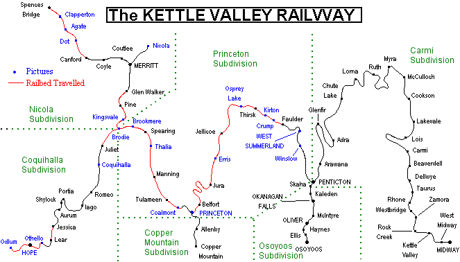
Kettle Valley Railway Map
Welcome to my Kettle Valley Railway Map.
Click on an area on the map that is marked in blue to see the pictures of that area.
Once you arrive at a page with pictures on it, click on the pictures to enlarge them. If you wish to see the next station on the line, you can click on the trains at the bottom of the page to go to the next station.
You can also click on the green text to go to that particular subdivision of the Kettle Valley Railway.

When I started touring the Kettle Valley Railway in the late 90’s, much of the right of way was actually drivable by vehicle. In fact it was John White’s book Driving the Kettle Valley Railway that really got me started in the KVR. Back then, much of the right of way was used by ranchers and people used ATV’s on the right of way.
When the province took ownership, it was initially left abandoned and many buildings, trestles and tunnels were vandalized. Finally with some lobbying from recreation enthusiasts, it became a recreational corridor.
The rails to trails society spent much time and effort getting help and donations to turn much of the old right of way into a cycling trail. Today, the sections of the Kettle Valley Railway that have become part of the Trans Canada Trail have hand rails on all the trestles. The old water tower foundations have been turned into covered pit stops where cyclists can rest. The KVR is now part of a trail system that not only crosses the province of British Columbia, but also crosses the rest of Canada.
If you have any more pictures (especially of areas I have not been
to) or suggestions for this web site then please email me at darrenc@telus.net
Remember, click anywhere on the Kettle Valley Railway Map to choose a station or point of interest.
